
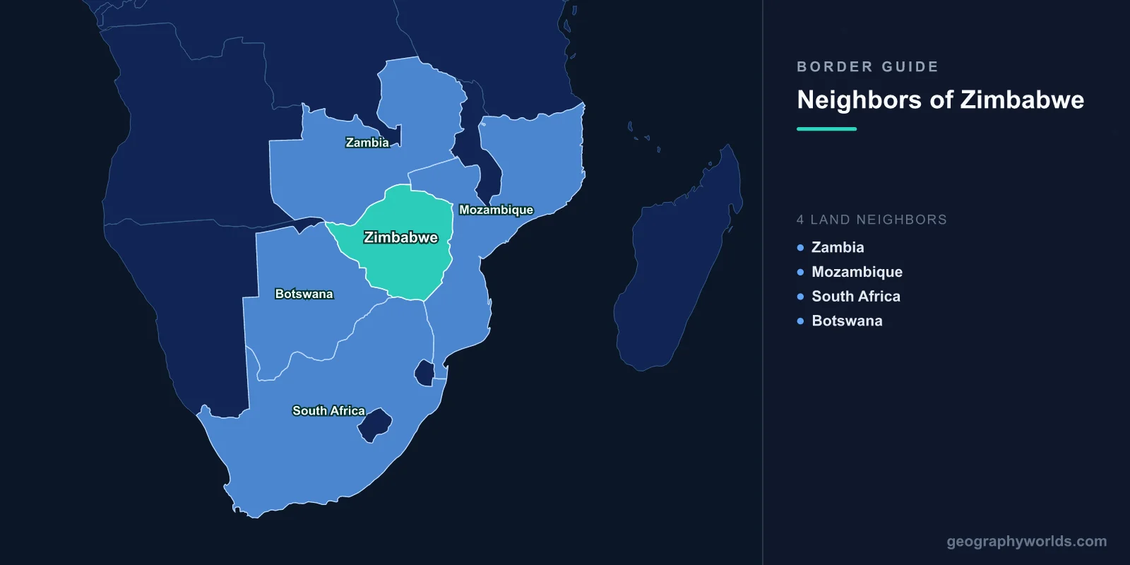
Four countries border Zimbabwe: Zambia across the north, Mozambique down the entire eastern side, South Africa in the south and Botswana to the west. The four add up to 3,229 km. Mozambique holds much the longest share at 1,402 km; South Africa the shortest at 230 km — and the shortest is the one that carries almost everything.
What makes Zimbabwe interesting is that its four frontiers are not variations on a theme. Each does a distinct job, and each is marked by something different on the ground: a river that generates power, a river that carries trade, a mountain range that once kept the country supplied, and a line of electrified fence. Take them one function at a time.
The Border That Makes the Electricity
The whole 763 km northern boundary is the Zambezi, and in the middle of it the river stops being a river. The Kariba dam wall, built between 1955 and 1959, stands 128 m high and 617 m across the gorge, and behind it sits Lake Kariba: 5,580 km², some 280 km long, and still the largest artificial reservoir on Earth by volume at around 180 cubic kilometres.
Filling it displaced roughly 57,000 Tonga people from the valley floor, many of whom were resettled onto poorer ground and never adequately compensated — a grievance that has outlasted three governments. It also produced Operation Noah, the improvised rescue in which game rangers pulled thousands of animals off shrinking islands as the water rose between 1958 and 1964.
The lake is jointly owned in a genuinely equal way, which is rarer than it sounds. The Zambezi River Authority is held fifty-fifty by Zimbabwe and Zambia, and the water allocation is divided evenly between the two power stations cut into opposite banks: Kariba South on the Zimbabwean side, 1,050 MW after its 2018 expansion, and Kariba North on the Zambian side at 1,080 MW. That shared asset is also a shared exposure. In the droughts of 2015–16, 2019 and 2024, usable storage fell to a few per cent and both countries load-shed for months at a stretch. A boundary that supplies a third of Zimbabwe's generating capacity in a good year supplies very little in a bad one.
The Border People Bungee Jump Off
Further west along the same river, the boundary crosses the Victoria Falls Bridge. Cecil Rhodes had instructed that it be sited where the spray would fall on passing carriages; he died in 1902 and never saw it. George Anthony Hobson designed it, the Cleveland Bridge Company of Darlington fabricated it in England, and the pieces were shipped out and cantilevered from both banks until the halves met on 1 April 1905. The main arch spans 198 m, 128 m above low water, and carries a single railway track, a road and a footway, with the international line running across the middle.
It has also served as neutral ground. In August 1975, South African and Zambian mediation put Ian Smith and the Zimbabwean nationalist leaders — Nkomo, Sithole, Muzorewa — into a South African Railways carriage parked on the bridge itself, precisely so that neither delegation had to set foot in the other's country. The talks broke down in under two days. The carriage stayed in the middle of a border because the border was the only place both sides would stand.
The Border That Everything Has to Cross
Zimbabwe's shortest boundary is its most important by a wide margin. Two hundred and thirty kilometres of the Limpopo separate it from South Africa, and effectively all of the crossing happens at one place: Beitbridge.
The Alfred Beit Road Bridge opened on 31 August 1929, funded from the estate of the Randlord whose name it carries, and the modern crossing now has two road bridges — the 1929 original and a second opened in 1995 — plus a rail bridge. It is the busiest land border post in southern Africa. On an ordinary day it processes something like 15,000 to 25,000 travellers and 500 to 700 trucks; in the fortnight before Christmas, when Zimbabweans working in South Africa come home, arrivals have exceeded 40,000 in a day and queues have run past ten kilometres. A US$300 million modernisation by the Zimborders consortium, awarded on a long build-operate-transfer concession, was completed in December 2022 and split the flow into separate freight, bus and private vehicle terminals.
Its importance runs far beyond Zimbabwe. Cargo for Zambia, Malawi and the Congolese copper belt lands at Durban and travels north through this single crossing, which is why a strike, a system outage or a public holiday at Beitbridge is felt in Lusaka a week later. South Africa's ports and its six land neighbours effectively function as the region's logistics spine, and Beitbridge is where the spine meets Zimbabwe.
The Limpopo itself is seasonal. For much of the year it is a sand bed with a channel in it, walkable in places, which is the physical fact underlying every account of undocumented crossing, razor wire, smugglers and crocodile attacks along this stretch.
The Border That Kept the Country Supplied
The Mozambican boundary is the longest at 1,402 km, and it is not a river line. From the Zambezi at Kanyemba it runs south along the crest of the Eastern Highlands, over the Nyanga and Chimanimani massifs, then down into the lowveld to meet the Limpopo. Mount Nyangani, at 2,592 m Zimbabwe's highest point, stands just inside it.
This is the frontier that decided the country's economic history twice. Mutare to the port of Beira is about 290 km, by a wide margin the shortest route from Zimbabwe to any ocean, and it carries a road, a railway and a refined-products pipeline commissioned in 1965. When Samora Machel's government closed that border in March 1976 in compliance with UN sanctions on Rhodesia, it cost Mozambique an estimated US$550 million and forced Rhodesian trade onto South African routes, tightening Pretoria's grip on Salisbury considerably.
After 1980 the logic reversed and independent Zimbabwe spent a decade trying to keep the Beira Corridor open against RENAMO sabotage, deploying between 10,000 and 12,000 troops inside Mozambique from 1982 and taking substantial casualties to protect a pipeline and a railway. Today Forbes/Machipanda handles the Beira road traffic and Nyamapanda feeds the Tete corridor towards Malawi, and neither carries anything close to the volume that goes south.
The Border With a Fence Down the Middle
Botswana accounts for 834 km. The northern portion follows the Ramokgwebana and Shashe rivers; south of that, through the Tuli block and down to the Limpopo, it is largely surveyed straight line. In 2003 Botswana erected a 500 km electrified fence along it. Officially it is a veterinary cordon against foot-and-mouth disease, and that justification is not merely a cover story — Botswana's beef exports to Europe depend on certified disease-free zones, and cordon fencing is standard practice there. It was nonetheless built at the height of Zimbabwe's economic collapse, when hundreds of thousands of Zimbabweans were leaving, and almost nobody in the region read it as being solely about cattle.
Plumtree, facing Ramokgwebana on the Bulawayo–Francistown road, is the main crossing, with Pandamatenga in the far north-west linking through to Kazungula. Botswana is a large and very empty country, and this border runs through some of the emptiest parts of both states.
Two Corners Worth Knowing
Zimbabwe has two tripoints, and both are river confluences. In the north-east, at Kanyemba opposite Zumbo, the Luangwa joins the Zambezi and Zambia, Zimbabwe and Mozambique meet. In the south-west, the Shashe runs into the Limpopo and Zimbabwe, Botswana and South Africa meet — and that spot has a considerably older claim on the map than any of the three states now touching it. Mapungubwe stood there between roughly 1075 and 1220 CE, the capital of a kingdom trading gold and ivory out to the Indian Ocean, and its hilltop site is now split by three modern jurisdictions.
| Neighbour | Border length | What marks the line | Main crossing and what it carries |
|---|---|---|---|
| Mozambique | 1,402 km | Eastern Highlands watershed | Forbes/Machipanda — the Beira corridor |
| Botswana | 834 km | Shashe and Ramokgwebana rivers, then survey lines and a 500 km fence | Plumtree — regional road traffic |
| Zambia | 763 km | The Zambezi, including Lake Kariba | Chirundu and Victoria Falls — freight and tourism |
| South Africa | 230 km | The Limpopo | Beitbridge — the bulk of national trade and migration |
The Arithmetic of Having No Coast
Zimbabwe has been landlocked since independence in 1980, and its four borders present it with a choice it keeps making the counter-intuitive way. Harare to Beira is about 580 km. Harare to Durban is closer to 1,700 km. The shortest route to salt water goes east through the longest border, and yet the great majority of the country's trade goes south through the shortest one, because South African ports, roads and rail have been the more reliable proposition for most of the last forty years.
That is the thing worth carrying away. Zimbabwe's frontiers are not four equivalent lines on a map but four different instruments — a power station, a tourist attraction, a customs bottleneck and a cattle fence — and which one matters most has changed with every decade since 1965. Anyone who wants to feel how tightly this corner of Africa is packed together should try guessing which capital sits nearest to which in a round of closest country; Harare, Lusaka, Gaborone and Maputo are far nearer to each other than the map in your head probably suggests.