
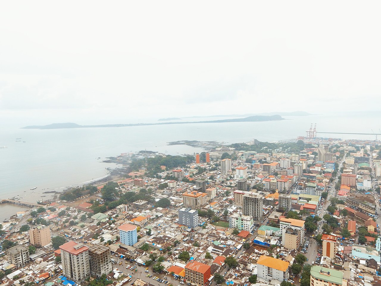
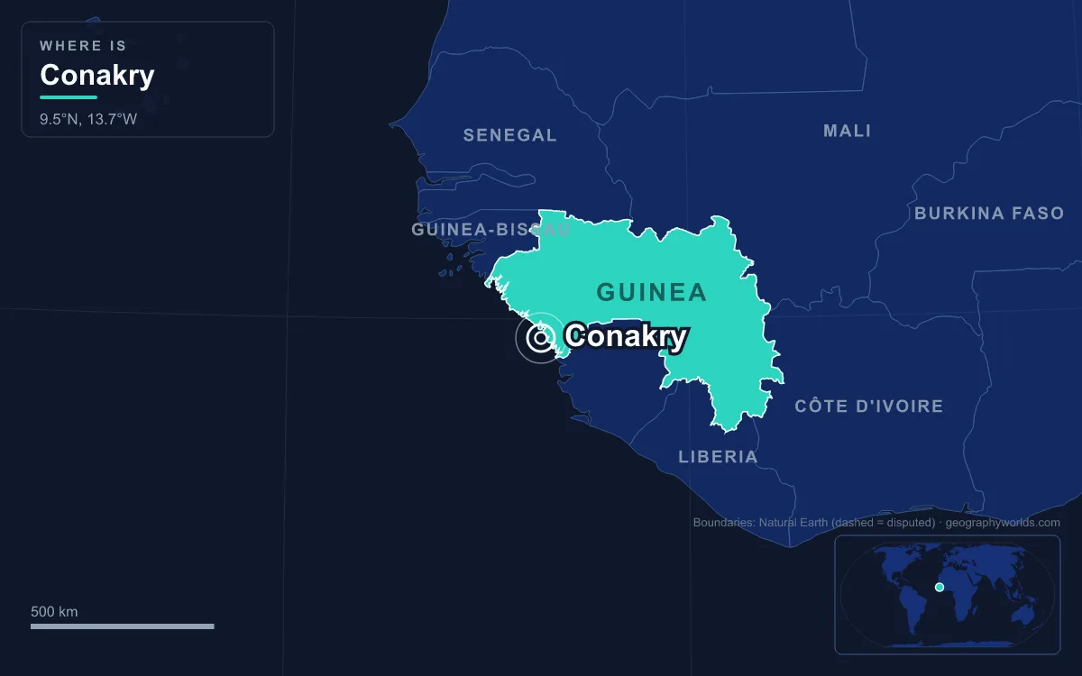
Conakry is the capital and largest city of Guinea, and the country's main port. It fills the Kaloum Peninsula, a thin finger of land that points south-west into the Atlantic, and it began on Tombo Island at the peninsula's tip. The 2025 census counted 3,407,327 people in the city, about one in five Guineans and more than eight times the population of Kankan, the next-largest city. Almost everything about Conakry comes back to that site. The small, isolated site suited the city's colonial founders. Since independence it has left Conakry short of space and hard to connect to the mainland, and it sits under a rainy season far wetter than most of West Africa's.
Tombo Island and the Causeway to the Mainland
The city started offshore. Tombo Island lies in the Atlantic at the end of the Kaloum Peninsula, about 4 kilometres east of the Îles de Los, and a causeway now joins it to the land. In 1885 it held two small villages, Conakry and Boubinet, with fewer than 500 people between them. France took control in the 1880s, as it competed with British and German interests on this stretch of coast. In 1880 the king of Dubréka had placed the island under French protection, and Germany gave up its claim to Tombo in 1885 in exchange for territory elsewhere.
The island's small size and its separation from the mainland were an advantage to the colonial founders. The French laid out their new town on Tombo and the peninsula tip, and in 1904 Conakry became the capital of French Guinea. The old town on the island and the colonial grid of Kaloum are still the administrative heart of the city today.
The Kaloum Peninsula: 36 Kilometres Long, Never More Than 6 Wide
The Kaloum Peninsula is about 36 kilometres long and between 0.2 and 6 kilometres wide. That shape has decided how the city grew. Conakry could not spread outward in a ring. It could only move up the peninsula to the north-east, one district after another. The first commune on the way in from the tip is Kaloum, now only 4.64 square kilometres, where 49,364 people were counted in 2025. It holds the Presidential Palace, the Palais du Peuple, many ministries, many embassies and banks, the commercial port and the fishing harbour. It also contains the colonial-era Ignace Deen Hospital, the Sandervalia National Museum and St Mary's Cathedral.
Further up the peninsula came Dixinn along the west coast, home to many embassies and to Gamal Abdel Nasser University, also known as the Institut Polytechnique de Conakry, then Ratoma, known for its nightlife. On the east side are Matam and Matoto, where the international airport runs along the southern shore. The airport was built in 1945 and is linked to the centre by the Autoroute Fidel Castro. Its position on the Atlantic mattered during the Cold War: in the 1970s the Soviet Union's naval aviation was allowed to use it as a staging base for Tu-95 reconnaissance flights over the ocean. The city's main markets include Marché Madina and Marché du Niger. These five communes were created when city government was decentralised in 1991. Beside Donka Hospital, east of the Conakry Botanical Garden, stands the Grand Mosque, one of the largest mosques in sub-Saharan Africa.

The Grand Mosque was built under President Ahmed Sékou Touré with money from King Fahd of Saudi Arabia and opened in 1982. It holds 10,000 men on the main floor and 2,500 women in the upper gallery, and another 12,500 worshippers can pray on the esplanade outside. Its gardens contain the Camayanne Mausoleum, with the tombs of the resistance leader Samori Ture, Alfa Yaya and Sékou Touré himself.
As the seat of power, the city has also been where Guinea's political crises played out. Camp Boiro, the prison camp feared under Sékou Touré's rule, was in Conakry. In later years the city saw the general strike of January and February 2007, when more than a hundred people died in clashes with the army, and the demonstration of 28 September 2009, when the military junta's troops opened fire on tens of thousands of protesters and, according to human rights groups, 157 people died.
The Îles de Los, Two Kilometres Offshore
Just off the peninsula's tip lie the Îles de Los. Their name comes from the Portuguese Ilhas dos Ídolos, "islands of the idols". There are three main islands. Roume is in the middle, and Kassa and Tamara (also called Fortoba) together form an almost complete ring around it. That ring shape comes from their origin as a volcanic structure, formed by an igneous intrusion. Kassa takes its name from the Portuguese casa, "house", and was once known as Factory Island. It has the main settlement. Tamara has the Île Tamara Lighthouse and once had a prison.

The islands lie about two kilometres off the headland on the southern side of Sangareya Bay. They are known for their beaches and forested interiors, and ferries run to them from Kaloum, so city residents can reach them easily. Britain held the islands from 1818 until the Entente Cordiale of 1904 handed them to France, which folded them into French Guinea that July. By the 2025 census they had been split from Kaloum as a commune of their own, Kassa, with 14.29 square kilometres of land and 9,257 residents. The surrounding waters have mattered in war as well. In November 1970, during Portugal's colonial war in neighbouring Portuguese Guinea, between 350 and 420 Portuguese soldiers and Portuguese-led Guinean fighters made an amphibious landing near the city in what Portugal called Operation Green Sea. They freed 26 Portuguese prisoners of war held by the PAIGC independence movement and destroyed some of its boats. They failed to capture its leader, Amílcar Cabral, or to overthrow Sékou Touré. A monument to 22 November 1970 in the city marks the attack.
3,730 Millimetres of Rain on the Kaloum Coast
The peninsula stands in the path of the West African monsoon, and the result is a very wet capital. Conakry has a tropical monsoon climate, with an annual average of about 3,730 millimetres of rain. Almost all of it falls between June and October, and July and August each get more than a metre. From December to April the harmattan wind blows off the Sahara and almost no rain falls at all. January and February average only a millimetre or two. August has the least sunshine of the year and March the most.
Rainfall also matters for the city's electricity, which depends on hydroelectric power. In February 2001 a drought cut the hydro supply to the city. Aging machinery, together with what critics described as mismanagement, then kept power and water cuts going as a regular part of life from early 2002. In 2007 much of the city still had no working traffic lights at night.
From Kaloum to Kagbélen: A Port City of 3.4 Million
The same peninsula that made the port also shaped the trade that fed it. From the colonial period a metre-gauge railway ran about 662 kilometres inland to Kankan and opened up the interior for large-scale groundnut exports through Conakry's harbour. A 143-kilometre branch to Fria, opened in 1963 and sharing the first 16 kilometres of the main line, brought alumina down to the coast. The port still ships alumina and bananas, and the city's factories produce food products, cement, metal goods and fuel products. The main line fared badly. Apart from fuel trains to Mamou, traffic stopped in 1993. A rebuilding project started by the Brazilian company Vale in 2011 was never finished, and most of the line remains abandoned. In June 2010 the Conakry Express, a 30-kilometre commuter service on a standard-gauge mineral line, began carrying passengers up the peninsula.
The city's name has even become part of the country's. Guinea is often called Guinea-Conakry to tell it apart from Guinea-Bissau and Equatorial Guinea, two other countries named after the Guinea region. The capital's weight within the country explains why. Guinea covers 245,857 square kilometres and had more than 17.5 million people at the 2025 census, but no other city comes close to its capital. The population figures show how fast Conakry filled its site. Conakry counted 78,388 people in 1958, the year Guinea declared independence on 2 October. By 1983 it had 710,372, and by 1996 more than a million. The 2014 census found 1,660,973. Every new resident had to fit onto the same small, isolated peninsula, and supplying roads, water and power became a lasting burden. By 2025 the total had passed 3.4 million, partly because the city's boundary was moved inland. Three communes were brought in from the Kindia Region: Kagbélen from Dubréka Prefecture, and Sanoyah and Manéah from Coyah Prefecture. Ratoma and Matoto were each split into three, and Conakry now has thirteen communes in all. The old peninsula tip has been losing people. Kaloum, including the Îles de Los, had 62,675 residents in 2014, but Kaloum and the new Kassa commune together counted only 58,621 in 2025. Meanwhile Kagbélen, Lambanyi and Sonfonia each counted more than 300,000.
Conakry's growth has always been limited by where it was built: an island at the end of a peninsula, a monsoon coast and a narrow neck of land. For the country behind it, see our Guinea country guide. For another West African capital built on a peninsula facing the Atlantic, read about Freetown just down the coast. And for the neighbour whose independence war reached Conakry's shore in 1970, turn to our history of Bissau.
Quick Facts About Conakry
- Country: Guinea
- Continent: Africa (West Africa)
- Country population: approximately 15.4 million
- Capital city status: Conakry is the capital of Guinea, the seat of national government, and the location of foreign embassies, parliament, and the head of state's official residence.
Frequently Asked Questions
What is the capital of Guinea?
The capital of Guinea is Conakry. Conakry is the seat of national government, hosts most foreign embassies and consulates, and is typically where the head of state and parliament are located.
What continent is Conakry in?
Conakry, the capital of Guinea, is located in Africa, in the West Africa region. As Guinea's capital, Conakry serves as the country's primary connection to the broader African political, economic, and cultural sphere.
Why is Conakry the capital of Guinea?
Conakry was chosen as the capital of Guinea for reasons that typically combine geography, history, and politics. Capital city selections often reflect a desire for centrality (being accessible from across the country), historical importance (being a longstanding seat of government or culture), or neutrality (being acceptable to multiple regions or ethnic groups within the country). The specific reasons for Conakry's designation are detailed in the city's history above.
What is Conakry known for?
As the capital of Guinea, Conakry is best known for housing the country's central government institutions — parliament, presidential or royal residences, supreme court, and key ministries. It is also typically a major cultural and economic center within Guinea, hosting national museums, embassies, and signature monuments. The introduction and history sections above provide detailed coverage of the city's specific notable institutions and landmarks.
Related Pages
- Guinea Country Guide — full geography, climate, economy, and culture overview
- Flag of Guinea — meaning, history, and design of Guinea's national flag