
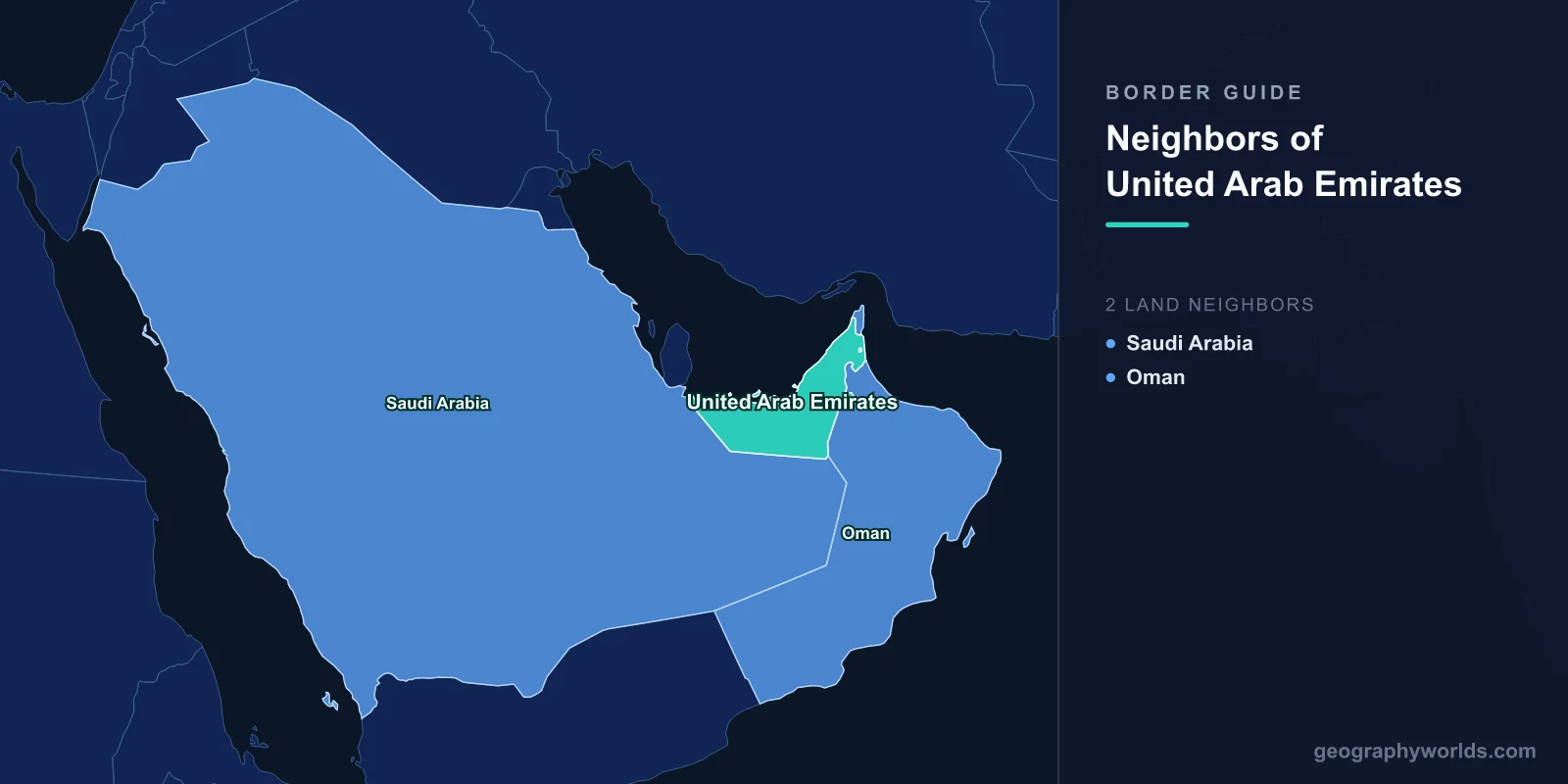
Only two countries share a land border with the United Arab Emirates: Saudi Arabia along the west and south, and Oman along the east and north. That is the entire list. The two lines add up to roughly 1,066 km of frontier, of which 609 km is Omani and 457 km Saudi, and the Gulf handles everything else — about 1,300 km of coast on two different seas.
The count is not what makes the UAE unusual. It is that both of its land boundaries are peculiar in ways few borders manage even one at a time. The Saudi line was settled by a treaty whose full text has never been released to the public. The Omani line is not a single line at all but three disconnected stretches, and one of them wraps around a piece of Oman that sits inside the Emirates, which in turn contains an Emirati village. Atlases have quietly disagreed about the UAE's outline for fifty years. The disagreement is not sloppiness. It is the map honestly reporting that nobody ever agreed.
A Treaty From 1974 That Nobody Has Been Allowed to Read
On 21 August 1974, Sheikh Zayed bin Sultan Al Nahyan and King Faisal signed the Treaty of Jeddah, closing roughly four decades of argument over three things at once: the Buraimi oasis on the inland edge of Abu Dhabi, the Zararah/Shaybah oil structure buried under the Empty Quarter, and a strip of coast at Khor al Udeid that would decide whether the UAE touched Qatar at all.
The terms, as later reported, ran roughly like this. Saudi Arabia dropped its claim to Buraimi and Al Ain. In exchange it took a corridor of territory reaching the Gulf at Khor al Udeid, and the larger share of production from Shaybah, a field straddling the boundary with reserves usually estimated above 15 billion barrels. What was never released was the wording. Saudi Arabia deposited a version with the United Nations only in the mid-1990s, more than twenty years after signature, and Abu Dhabi has maintained ever since that the written text does not match what was agreed verbally in the room — a gap Emirati accounts attribute to a negotiating team that turned up without lawyers, surveyors or a geographer among them.
The result is a border that behaves differently depending on whose map is on the table. In 2005 the Emirati foreign minister said openly that parts of the 1974 agreement could no longer be implemented. When the UAE issued a national identity card in 2009 carrying a map that ran the coastline through Khor al Udeid, Saudi Arabia objected and Saudi officers at the Al Batha crossing refused for a period to accept the card as a travel document. Two governments, one signed treaty, two official versions of where the line goes. If you want a sense of how normal that is for the region, it is worth reading how the Saudi frontier behaves with its other neighbours, most of which took until the 1990s or 2000s to settle.
One practical consequence deserves stating plainly, because it is the question people usually ask next: the UAE and Qatar do not share a land border. On a small-scale map the two look adjacent across the base of the Qatari peninsula. They are not. The Saudi corridor at Khor al Udeid, roughly 25 km of coast, runs between them, so a driver going from Abu Dhabi to Doha enters Saudi Arabia at Al Batha and leaves it at Abu Samra. Whether that corridor should exist at all is precisely the thing Abu Dhabi has never conceded.
Buraimi, 1952: The Standoff That Made a Treaty Necessary
The 1974 deal only makes sense against what happened twenty years earlier. In August 1952 a Saudi official, Turki bin Abdullah al-Otaishan, arrived at Hamasa — one of the nine villages of the Buraimi oasis — with a party of about forty armed men and a radio set, and declared the oasis Saudi. Behind him stood Aramco geologists who had good reason to believe the sands nearby held oil. Behind the other side stood Britain, which ran the foreign relations of the Trucial States and held a treaty with the Sultan in Muscat.
A standstill agreement in October 1952 froze everyone where they stood. Arbitration opened in Geneva in 1955 and collapsed within days amid accusations that witnesses had been paid. In October 1955 the British-officered Trucial Oman Levies walked into the oasis and escorted the Saudi party out. Britain and Saudi Arabia broke off diplomatic relations for the better part of eight years over it.
The oasis today is split six villages to three. The six on the western side make up Al Ain, the inland city of Abu Dhabi emirate and Sheikh Zayed's birthplace. The three on the eastern side are the Omani town of Buraimi. For decades the line between them was effectively invisible: families crossed daily for school, work and weddings, and there were no posts at all. That ended in September 2006, when Oman fenced the boundary and funnelled traffic through formal crossings at Hilli and Khatm al Shiklah — a change driven less by any quarrel with the UAE than by Oman's wish to control the onward movement of migrant labour.
Oman's Border Arrives in Three Separate Pieces
The 609 km credited to Oman is a total, not a continuous line. It breaks into three:
- The main southern and eastern stretch, running from the tripoint with Saudi Arabia deep inside the Rub' al Khali, north-east across gravel plains behind Al Ain, over the Hajar Mountains, and out to the Gulf of Oman near Khatmat Malahah.
- The Musandam perimeter, where the Emirates wrap completely around Oman's northern tip.
- Madha, a piece of Oman sitting alone inside the Emirates near the east coast.
Musandam is the one most people have looked at without registering what they were seeing: the hook of mountain that closes the Strait of Hormuz, about 1,800 km² of near-vertical limestone governed from Khasab, and separated from the rest of Oman by roughly 100 km of Emirati territory. Driving there from Muscat means crossing into the UAE at Khatmat Malahah, running the length of the country, and crossing back at Tibat beyond Ras Al Khaimah. The peninsula is Omani because in the nineteenth century its tribes — including the Kumzari of the far north, who speak an Iranian language with no Arabic parentage — gave their allegiance to the Sultan, while the coastal sheikhdoms further south went with the Qawasim and became Trucial states. The border here records a set of loyalties, not a feature of the ground.
The Village Inside the Village Inside the Country
Madha covers about 93 km² and holds roughly 4,300 people. It belongs to Oman and touches Omani territory nowhere at all: Sharjah, Fujairah and Ras Al Khaimah surround it on every side. Inside Madha, a further 4.4 km² is Nahwa, a village of around 300 people that is part of Sharjah and therefore part of the UAE. It is one of a tiny handful of second-order enclaves on Earth — Emirates inside Oman inside the Emirates.
The arrangement is not ancient. In the 1930s and 1940s, as Britain and the Sultan tried to establish who owned what before oil concessions were let, villages were simply asked which ruler they followed. Madha answered Muscat. Nahwa answered the ruler of Sharjah. Nobody was going to relocate a village to tidy the map, so the map was drawn around the answers.
On the ground there is no fence, no gate and no stamp. The road up from Khor Fakkan runs through the Emirates, into Oman, into the Emirates again, and back out. The reliable signals are the licence plates, the change in the colour of the road markings, and a phone that hops onto an Omani network and off again. Drivers who are not watching find out from the roaming charges.
Where People Actually Cross
For all the cartographic disorder, the working crossings are few and easy to name:
- Ghuwaifat / Al Batha — the only formal road crossing into Saudi Arabia, on the coastal highway west of Abu Dhabi, and the land gateway to both Qatar and the Saudi eastern province.
- Hatta / Al Wajajah — the standard Dubai-to-Muscat route, running through Hatta, a mountain outpost of Dubai reached along a corridor of road threading between Omani, Ajman and Ras Al Khaimah territory.
- Hilli and Khatm al Shiklah — the Al Ain to Buraimi posts, opened in 2006 across a line that had been unmarked for generations.
- Khatmat Malahah — the east-coast crossing between Fujairah and Shinas, the main freight artery between the Emirati ports and Sohar.
- Tibat — the northern gate into Musandam.
| Neighbour | Land border | How many separate sections | Status of the line |
|---|---|---|---|
| Oman | 609 km | Three (main line, Musandam, Madha) | Demarcated on the ground, 2003–2008 |
| Saudi Arabia | 457 km | One | Governed by the 1974 Treaty of Jeddah, text unpublished |
Why the Published Length Keeps Changing
Reference works do not agree on the totals. Older editions of the CIA World Factbook gave the UAE 867 km of land boundary, of which 410 km was Omani; current figures give 1,066 km and 609 km. Nothing moved. The revision reflects the detailed demarcation Oman and the UAE carried out between 2003 and 2008, and a decision to count the perimeters around Musandam and Madha as boundary rather than treating them as separate curiosities. If you want one sentence for why the UAE's borders look strange, it is this: the country has considerably more boundary than a land mass of that shape ought to have, because two chunks of it are wrapped around somebody else's territory. That is also why the UAE is far harder to place accurately from memory than its size suggests, and why it rewards a slow look on a blank map of the world.
The Gulf coastline is instantly recognisable — that long shallow curve hooking north-east towards Hormuz. The land outline behind it, with its notches and holes and a border that two governments still draw differently, is not. That contrast is exactly what makes the Emirates such a satisfying one to pick out in a round of country shapes.