
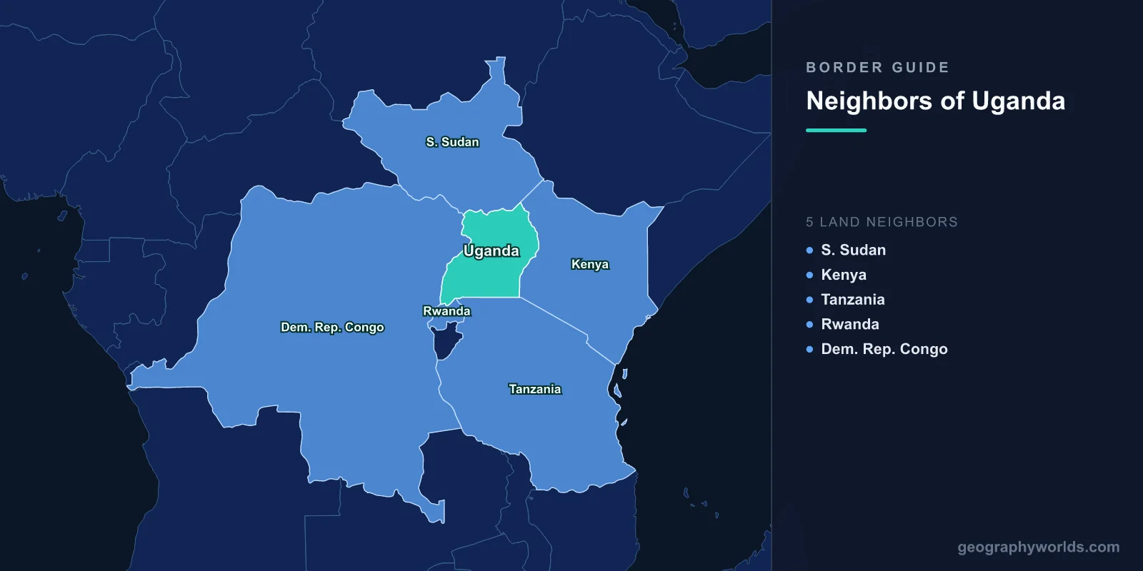
Uganda has five land neighbours: South Sudan to the north, Kenya to the east, Tanzania to the south, Rwanda to the south-west and the Democratic Republic of the Congo to the west. Between them they account for 2,729 km of boundary and close the country in completely. Uganda has no coast at all; the nearest working port, Mombasa, is about 1,170 km from Kampala by road.
Not one of those five lines was drawn by a Ugandan. All of them were settled between 1890 and 1926 in London, Berlin and Brussels, largely by officials who had never seen the ground, and the consequences are still legible on any decent map. Taking them in the order they were fixed explains almost every oddity in the modern outline — including a half-acre rock in Lake Victoria that two governments have been unable to stop arguing about.
1890: A Line of Latitude Handles the South
The Anglo-German Agreement of 1 July 1890 is usually remembered for Heligoland, the island in the North Sea that Britain handed to Germany. What Britain got in return was a redrawing of spheres in East Africa, and one clause of it produced Uganda's southern boundary. The agreed line ran inland from the coast, around Kilimanjaro, to the eastern shore of Lake Victoria at one degree south, then straight west along that parallel.
That is still what the border does. For much of its 391 km, the Uganda–Tanzania boundary is simply the first parallel south: a ruled line across the lake and the land west of it, taking no account of who was living where, before the Kagera River picks it up towards the western end. The main crossing at Mutukula sits on it, on the road from Kampala down to Bukoba and Mwanza. Tanzania's other frontiers have their own share of this kind of drafting, and the pattern is visible across all eight of its neighbours.
1902 and 1926: Uganda Hands Two Provinces to Kenya
The largest single change to Uganda's shape was administrative, and it happened in a single Order in Council. In 1902 the Uganda Protectorate's Eastern Province — Kisumu, Naivasha, the Nandi and Kericho highlands, the north-eastern shore of Lake Victoria — was transferred to the East Africa Protectorate, which would become Kenya. The reason was the railway: the line from Mombasa had reached Kisumu in December 1901, and the British wanted the whole of it under one governor rather than two. A second transfer in 1926 moved Rudolf Province, the Turkana country in the far north-east, across as well.
Uganda lost roughly a third of its territory and any prospect of ever holding its own outlet to the sea. It also acquired the border it has now, 814 km of it, which is why the Kenyan line makes so little geographic sense: it cuts the Elgon massif in half and slices the lake shore in a way no one living there would have drawn. Kampala has never formally challenged the 1902 line, though Ugandan politicians raise it whenever the two capitals fall out. Seen from the other side, the transfers explain a good deal about how Kenya's own borders came to look the way they do.
Mount Elgon straddles the line the transfer created. An extinct shield volcano with one of the largest calderas in the world, it tops out at Wagagai, 4,321 m, on the Ugandan side, while the second summit, Sudek, sits on the boundary itself. The Suam River crossing runs over its northern flank, and the mountain's caves — where elephants go underground at night to mine salt from the rock — are split between two national parks and two countries.
1910: Three Empires Meet on a Volcano
The Brussels conference of 1910 settled a long-running argument over the Mfumbiro volcanoes, which Britain claimed under the 1890 agreement and Germany had quietly occupied. The compromise fixed the meeting point of British Uganda, the Belgian Congo and German East Africa at the summit of Mount Sabyinyo, 3,669 m, an eroded volcano in the Virunga chain whose Kinyarwanda name refers to the old man's teeth its jagged crown resembles.
That summit is now the Uganda–Rwanda–DR Congo tripoint, and hikers who make the climb from Kisoro stand on a small wooden platform with a foot in three countries. The Rwandan border running away from it is Uganda's shortest at 172 km — and, as it turned out a century later, the most fragile.
1907–1915: Surveying the Mountains of the Moon
The Anglo-Belgian boundary commissions that worked between 1907 and 1915 produced Uganda's longest border, 877 km with what is now the DR Congo. Where water was available they used it: Lake Albert, the Semliki River, Lake Edward. Where it was not, they used the crest of the Rwenzori, the range Ptolemy had called the Mountains of the Moon on the strength of second-hand reports of snow on the equator.
Margherita Peak, at 5,109 m the third-highest summit in Africa, sits precisely on that boundary; climbers who reach it from Uganda have one boot in the Congo. The commissioners set the line on the water-parting, which was a sensible choice in 1908 and is quietly becoming a historical one: the glaciers feeding those headwaters have lost more than eighty per cent of their area since the first survey of 1906, and are expected to disappear entirely within a couple of decades.
Lower down, the same border runs through oil. The Ugandan side of the Lake Albert basin holds an estimated 6.5 billion barrels, and the lake boundary has produced the sharpest incidents of recent years — including a firefight around Rukwanzi Island in August 2007 in which a British contractor working for an exploration company and a Congolese soldier were killed. The Congolese frontier is long and thinly governed everywhere along it, and the Ugandan section is no exception.
1914: The Northern Line, and a Neighbour That Changed Its Name
Uganda's 475 km northern boundary was fixed by Anglo-Egyptian arrangement in the years around 1914, when the West Nile district — the country around Arua, Koboko and Moyo — was transferred from Sudan to Uganda. That corner had already passed through the hands of Leopold II, whose Lado Enclave lease over the upper Nile expired on his death in 1909.
The line has not moved since. What changed was the label: South Sudan's independence in July 2011 gave Uganda a new neighbour without shifting a single boundary pillar. The crossing at Elegu, opposite Nimule, now carries the great majority of South Sudan's imports, and Uganda is comfortably its largest supplier of goods. The one genuinely contested stretch is Apaa, a wedge of land between Uganda's Amuru district and South Sudan's Magwi county where the colonial-era description and the ground disagree; joint demarcation has stalled repeatedly since 2014 and people have been displaced by the argument.
2009: Half an Acre That Nearly Started a War
Migingo Island is a rock in Lake Victoria measuring about 2,000 m² — roughly half an acre, a quarter the size of a football pitch. It was effectively uninhabited until the 2000s, when the Nile perch shoals around it drew fishermen who built corrugated-iron shacks across virtually every square metre of exposed stone. As many as 500 people have lived there at once, making it one of the most densely occupied places on the planet.
Kenya established a police post. Uganda raised a flag and sent marine police. Newspapers on both sides took it up with enthusiasm, and it was widely described as Africa's smallest war. A joint boundary survey launched on 2 June 2009 reported at the end of July that the island lies 510 m on the Kenyan side of the line inherited from 1926 — which settled the rock and settled nothing else. The fishing waters were left unresolved, Ugandan patrols continued to detain Kenyan crews, and flare-ups have recurred through the 2010s and into the 2020s. The full re-demarcation of the 814 km Kenya–Uganda boundary, agreed in principle more than a decade ago, is still not finished.
2019: The Shortest Border Shuts
In February 2019 Rwanda closed Katuna, its main crossing with Uganda, alleging that Kampala was detaining Rwandan nationals and supporting rebel groups. Uganda denied both. The 172 km border stayed effectively shut for almost three years. Ugandan formal exports to Rwanda, worth close to US$200 million a year beforehand, fell to near nothing; the informal trade at Cyanika and Mirama Hills, which is what actually feeds border towns, collapsed alongside it. The crossing reopened on 31 January 2022.
2021: Traffic in the Other Direction
After bombings in Kampala on 16 November 2021 attributed to the Allied Democratic Forces, Uganda and the DR Congo launched Operation Shujaa on 30 November: artillery and airstrikes followed by Ugandan ground troops crossing at Mpondwe and Nobili into North Kivu and Ituri. The direction of travel was the striking part, since the ADF began as a Ugandan rebel movement that fled west across the same border in the 1990s. The operation came bundled with a road-building programme — Uganda undertook to upgrade some 223 km of Congolese road, including the Kasindi–Beni–Butembo route. When M23 fighters took Bunagana in June 2022, one of the busiest crossings on that border shut and its traffic shifted to Mpondwe.
| Neighbour | Border length | When the line was fixed | Main crossing |
|---|---|---|---|
| DR Congo | 877 km | 1907–1915 Anglo-Belgian commissions | Mpondwe |
| Kenya | 814 km | 1902 and 1926 Orders in Council | Malaba and Busia |
| South Sudan | 475 km | c.1914 Anglo-Egyptian arrangement | Elegu–Nimule |
| Tanzania | 391 km | 1890 Anglo-German Agreement | Mutukula |
| Rwanda | 172 km | 1910 Brussels conference | Katuna–Gatuna |
Where the Water Does the Dividing
A large share of Uganda's perimeter is not land at all. Lake Victoria, 68,800 km² and the second-largest freshwater lake on Earth by area, is split three ways: Tanzania holds about 49 per cent, Uganda 45 per cent and Kenya 6 per cent. Lake Albert and Lake Edward are shared with the DR Congo. On these stretches the border is a set of coordinates rather than a fence, enforced by patrol boats and felt almost exclusively by fishermen — which is precisely why Migingo became a national argument in two capitals while remaining, on the ground, a rock with too many huts on it.
Five neighbours, five very different frontiers: a parallel of latitude, an administrative reshuffle, a volcano summit, a mountain water-parting and a river valley. If you can hold the shape of that in your head, dropping a pin on Kampala, Kigali, Kisumu and Goma in a round of map guessing stops being guesswork.