
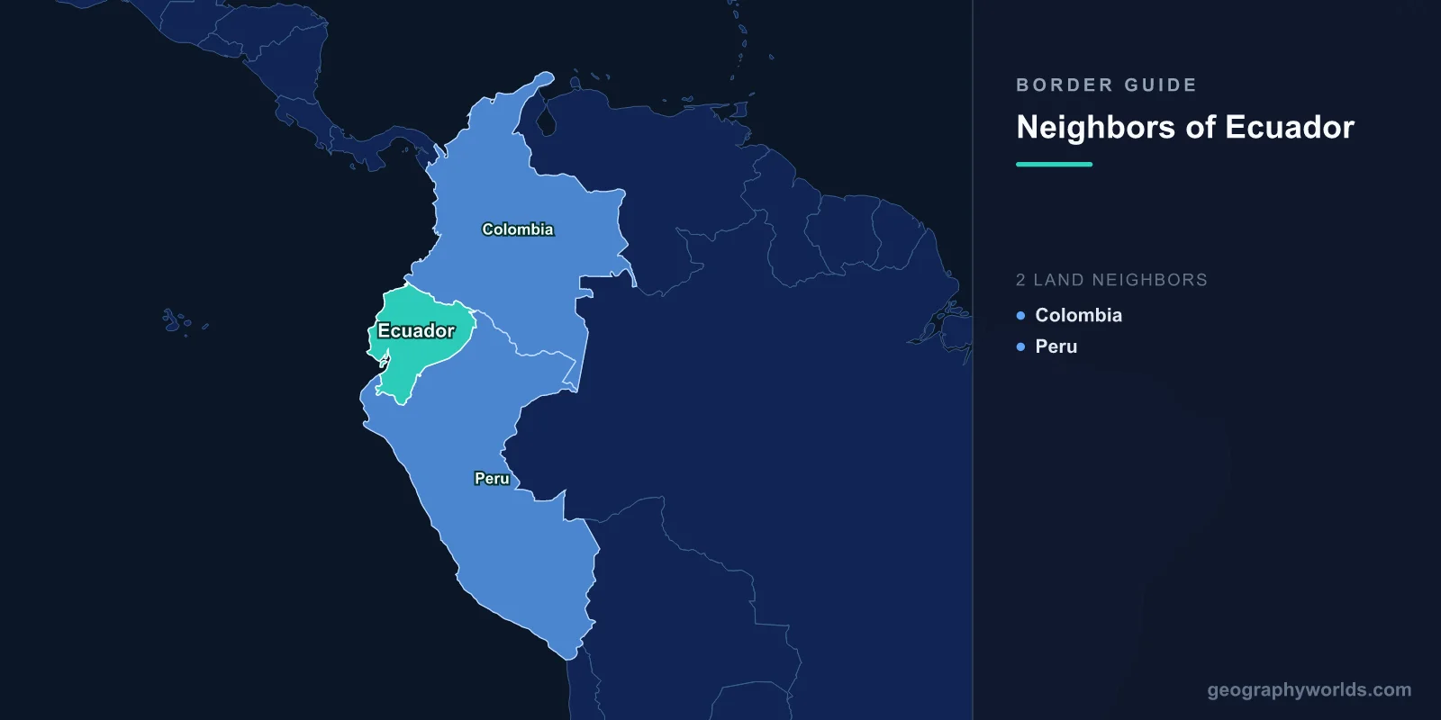
Ecuador touches exactly two other countries. Colombia sits along the north, Peru wraps around the south and the east, and together they account for 2,237 km of land boundary: 708 km with Colombia and 1,529 km with Peru. Everything else is Pacific coastline, plus roughly 1,000 km of open water out to the Galapagos.
Two neighbours ought to make for a simple map. It did not. The southern line was, until October 1998, the oldest unresolved boundary quarrel between two independent states anywhere in the Western Hemisphere. It produced three shooting wars in a single century and left Ecuador a fraction of the size its own schoolbooks insisted on.
A Country That Used to Reach the Amazon
When Gran Colombia broke apart in 1830, the successor republics agreed in principle to inherit the administrative lines of the Spanish empire. The trouble was that those lines had been redrawn repeatedly, and Quito and Lima each held a royal decree that suited them. Ecuador leaned on the boundaries of the old Audiencia de Quito; Peru leaned on the Royal Order of 1802, which transferred the missionary provinces of Maynas to the Viceroyalty of Peru. Both documents were real. They described different countries.
The gap between them was enormous. Ecuador's claim ran east across the rainforest to the Maranon and the main stem of the Amazon, an area of well over 200,000 sq km that Ecuadorian governments never physically controlled but never stopped drawing. Generations of children copied out the state slogan: Ecuador has been, is, and will be an Amazonian country. It was printed on maps, stamped on official stationery, and taught as settled fact.
1942: A Protocol Signed With Foreign Troops Still Inside
In July 1941 the argument turned into an invasion. Peruvian forces pushed into the coastal province of El Oro, took Machala and the port of Puerto Bolivar, and dropped paratroopers on Puerto Bolivar in what is usually counted as the first airborne operation in the Americas. Ecuador's army, smaller and badly supplied, could not hold.
The settlement came six months later at a conference in Rio de Janeiro that had been convened for an entirely different purpose: coordinating the American republics against the Axis after Pearl Harbor. On 29 January 1942, with the diplomatic weather firmly against it, Ecuador signed the Protocol of Peace, Friendship and Boundaries, guaranteed by Argentina, Brazil, Chile and the United States. It surrendered the Amazonian claim more or less entirely.
What Ecuador lost was not jungle in the abstract. It lost any frontage on the Amazon proper, and with it the prospect of shipping goods to the Atlantic under its own flag. The country that had called itself Amazonian woke up landlocked from the river system that gave it the name.
The 78 Kilometres Nobody Could Draw
Demarcation teams went out and marked most of the new line without incident. Then they reached the Cordillera del Condor, a steep, cloud-wrapped range in the far southeast, and stopped.
The protocol described the boundary there as running along the watershed divide between the Zamora and Santiago rivers. That phrasing assumed a single ridge separating two basins. In 1947 an aerial survey flown with United States assistance found a third river of real size, the Cenepa, cutting between them. There was no single divide to follow, because the geography the treaty described did not exist. Roughly 78 km of border was left unmarked, and the two sides read the blank space in opposite directions.
Ecuador's position hardened from there. In 1960 President Jose Maria Velasco Ibarra declared the whole Rio Protocol null on the grounds that it had been imposed under occupation. The four guarantors rejected the argument. The unmarked stretch stayed unmarked for another four decades.
Paquisha, Cenepa, and the Last Border War in the Americas
The Condor gap flared twice. In January 1981 fighting broke out around a set of Ecuadorian outposts near the Paquisha area and lasted about a week. Then, on 26 January 1995, it escalated into something much larger. The Cenepa War ran for roughly a month in terrain so vertical that both armies supplied their forward positions by helicopter and by hand.
It was a genuinely modern conflict fought in a place with no roads: Ecuadorian Mirages and Kfirs against Peruvian Sukhois, shoulder-launched missiles against helicopters, minefields sown on slopes that neither side could hold for long. Several hundred soldiers died. The fight centred on a small base called Tiwintza, which both governments claimed to have captured and which became, for Ecuadorians, the emotional centre of the entire dispute.
The guarantors brokered a ceasefire in the Itamaraty Peace Declaration of 17 February 1995 and put an observer mission into the valley to separate the two forces. That froze the fighting. It did not answer the question.
What Ecuador Got in Brasilia
The answer arrived on 26 October 1998, when Presidents Jamil Mahuad of Ecuador and Alberto Fujimori of Peru signed the Presidential Act of Brasilia. The legal core of the deal went against Ecuador: the line through the Condor followed the interpretation the guarantors' technical experts had recommended, which was essentially Peru's.
The compensation was unusual and carefully designed. Ecuador received one square kilometre of land at Tiwintza as private property, held under Peruvian sovereignty, so that it could honour its dead on the ground where they fell. It received permanent free navigation on the Amazon and its northern tributaries, plus the right to operate two commerce and navigation centres on the river. Both countries agreed to create adjoining ecological reserves along the Condor. Demarcation crews finished the last markers in May 1999, closing a dispute that had outlived every person who started it.
The sea was easier. Ecuador, Peru and Chile had jointly declared 200-nautical-mile maritime zones in the Santiago Declaration of 1952, well before that limit was accepted internationally, and Ecuador and Peru have always treated the parallel of latitude at the coast as their offshore boundary. When Peru later challenged the same principle against Chile at the International Court of Justice, it took care to confirm the Ecuadorian line separately by exchange of notes in 2011, so that the case could not unsettle it.
| Neighbour | Border length | What the line follows | Settled by |
|---|---|---|---|
| Peru | 1,529 km | Zarumilla river, Andean crest, Cordillera del Condor, Amazon headwaters | Rio Protocol 1942, completed by the Brasilia Act 1998 |
| Colombia | 708 km | Carchi river and Andean ridges in the west; San Miguel and Putumayo rivers in the east | Munoz Vernaza-Suarez Treaty, 15 July 1916 |
North to Colombia: A Stone Bridge and a Jungle River
Ecuador's northern boundary has been quiet by comparison. It was fixed by the Munoz Vernaza-Suarez Treaty of 15 July 1916 and has not moved since, which makes it one of the more durable agreements on the continent. Anyone tracing the wider picture will find that Colombia's own set of neighbours is considerably more crowded.
In the Andes, the line runs along the Carchi river, and the crossing point is a piece of geology rather than engineering. Rumichaca, from the Kichwa for stone bridge, is a natural rock arch spanning the Carchi gorge between Tulcan on the Ecuadorian side and Ipiales on the Colombian. A modern road bridge now sits beside it. This is by far the busiest land entry into Ecuador, and in 2018 and 2019 it became the funnel for the Venezuelan exodus moving south, with thousands of people a day queuing on the bridge approach.
The eastern half of the border is a different world. There the line follows the San Miguel and then the Putumayo river through the lowland province of Sucumbios, with no continuous road on either bank. It is coca country, and for decades it has been contested by Colombian armed groups. In March 2008 a Colombian air and ground strike hit a guerrilla camp roughly two kilometres inside Ecuadorian territory and killed the commander known as Raul Reyes. Ecuador broke diplomatic relations, and the two governments did not fully restore them until late 2010.
Where You Can Actually Cross
For all the length of the Peruvian boundary, the traffic concentrates in a handful of places. Huaquillas in El Oro faces Aguas Verdes across the Zarumilla river and carries the coastal Pan-American route; the two governments eventually replaced the chaotic street crossing there with a joint border facility set back from the river. Inland, Macara connects to La Tina on the road down from Loja, a slower and much calmer option. Far to the southeast, La Balsa in Zamora Chinchipe serves the backpacker route towards Jaen and northern Peru.
On the Colombian side the picture is simpler still: Rumichaca handles almost everything, with the San Miguel bridge near Lago Agrio serving the Amazon lowlands. Two neighbours, four practical doors, and a shape that took nearly two centuries to agree on. If you want to see how unusual it is for a South American country to have so few neighbours, try naming the ones that ring Peru or Brazil from memory.
Ecuador is a useful reminder that the number on a map tells you almost nothing about the story behind it: two borders, one of them settled quietly in 1916 and the other only in 1999, after a war fought above 1,000 metres in a valley most of the world had never heard of. If you can place Rumichaca and Tiwintza on a map, you are ahead of most people, and you will find the neighbours game a fair test of whether the rest of the continent is as clear in your head.