
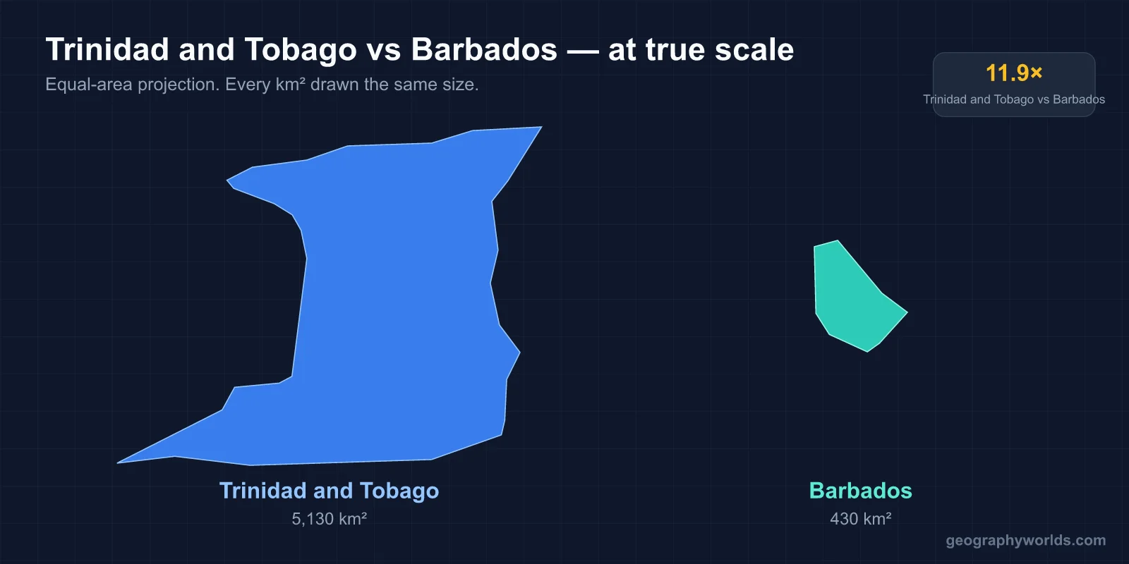
Trinidad and Tobago is by far the bigger of the two: its 5,131 km² is almost twelve times the 439 km² of Barbados, and its population of about 1.51 million (2025 estimate) is roughly five times Barbados’s 282,000 (2023 estimate). On income the pair is close, and which one looks richer depends on the measure. Barbados edges ahead on nominal GDP per capita (about US$21,400 against US$19,600, IMF 2023), while Trinidad and Tobago is well ahead once prices are adjusted (about US$30,700 against US$18,700 at purchasing power parity). The capitals are Port of Spain and Bridgetown, and both countries use English as the official language, alongside Trinidadian and Bajan Creoles in everyday speech. The two countries are less than 300 km apart (Trinidad and Tobago lies about 287 km south-west of Barbados), but the islands were built by different geological processes and grew rich in different ways.
Trinidad and Tobago and Barbados in ten figures
The table sets the headline numbers side by side. The sections after it deal with the widest gaps one at a time and explain where each comes from.
| Trinidad and Tobago | Barbados | |
|---|---|---|
| Area | 5,131 km² | 439 km² |
| Population | About 1.51 million (2025 est.) | About 282,000 (2023 est.) |
| Density | About 294 per km² | About 660 per km² |
| Highest point | El Cerro del Aripo, 940 m | Mount Hillaby, 340 m |
| GDP per capita, nominal (IMF 2023) | US$19,621 | US$21,442 |
| GDP per capita, PPP (IMF 2023) | US$30,718 | US$18,738 |
| Human Development Index (2023) | 0.807 | 0.811 |
| Independence | 31 August 1962 | 30 November 1966 |
| Became a republic | 1 August 1976 | 30 November 2021 |
| Capital | Port of Spain | Bridgetown |
Two rows stand out. On area and population Trinidad and Tobago is far larger, yet on the Human Development Index the two are almost level, 0.807 against 0.811. Barbados has fewer people and far less land, so it is more than twice as crowded, with about 660 people per km² against about 294.
Why Trinidad is twelve times larger: a piece of South America against a raised sea floor
The size gap comes from how the islands formed. Trinidad sits on the continental shelf of South America and is geologically part of that continent. At its closest point, across the Columbus Channel, it lies only about 11 km from the coast of Venezuela. The main island covers 4,768 km², which is 93 percent of the country, and averages about 80 km long and 59 km wide. Tobago adds about 300 km² and lies some 37 km to the north-east. Smaller islands such as Chacachacare, Monos, Gaspar Grande and Little Tobago make up the rest.
Barbados is much smaller because it formed a different way. It lies east of the Lesser Antilles volcanic arc, but it is not a volcano. The island is the exposed top of the Barbados Ridge accretionary prism. This is a wedge of sediment scraped off the South American Plate as it slides beneath the Caribbean Plate, a process that is still lifting the island by about 30 cm every thousand years. Reefs grew on top of that wedge, and today a cap of coralline limestone covers roughly 85 percent of the island’s surface. The result is an island only 34 km long and at most 23 km wide.
The difference also shows in the landscape. Trinidad has large wetlands, including the Caroni and Nariva swamps, reservoirs at Hollis, Navet and Caroni, and three separate hill systems. Barbados has no rivers of any size. Rain soaks straight into the porous coral rock, and most of the island’s few small streams run through the Scotland District.
940 metres against 340: El Cerro del Aripo and Mount Hillaby
Trinidad’s Northern Range runs along the north coast as a continuation of the mountains of Venezuela. It contains the country’s two highest peaks, El Cerro del Aripo at 940 m and El Tucuche at 936 m. The Central Range, the Montserrat Hills, and the Southern Range with the Trinity Hills divide the rest of the island into separate river basins. Tobago is flat in the south-west and rises in its eastern half to Pigeon Peak, 550 m, near Speyside.
Barbados is low by comparison. Its land climbs gently from the west coast to Mount Hillaby, 340 m, in the parish of Saint Andrew. Below the summit to the north and east lies the Scotland District, where the coral cap has worn away and older, easily eroded sediments reach the surface. Erosion there has cut the island’s most broken, hilly country.

The height difference affects rainfall, forest and farming. Trinidad’s mountains catch moisture and feed rivers into its swamps. The fertile alluvial valleys of the Northern Range and the East–West Corridor carry much of the island’s farming. In Barbados, about 15 percent of the land is forest (6,300 hectares in 2020), and none of it is classed as primary forest. Centuries of sugar planting cleared nearly all the original cover, and the tourist hotels crowd the urbanised south coast rather than the rough Atlantic shore.
Oil and gas in Trinidad, tourism in Barbados: the GDP per capita puzzle
The income figures reverse depending on the measure because the two economies earn their money differently. Most English-speaking Caribbean economies depend on tourism, but Trinidad and Tobago is mainly industrial. In 2023 it was the Caribbean’s largest natural gas producer and its second-largest oil producer after Guyana. Oil and gas account for about 40 percent of GDP and 80 percent of exports, but only about 5 percent of jobs. Liquefied natural gas and petrochemical plants drove per-capita growth of about 7.1 percent a year in the decade to 2006. When energy prices fell, output per person shrank by about 1.8 percent a year in the decade to 2023.
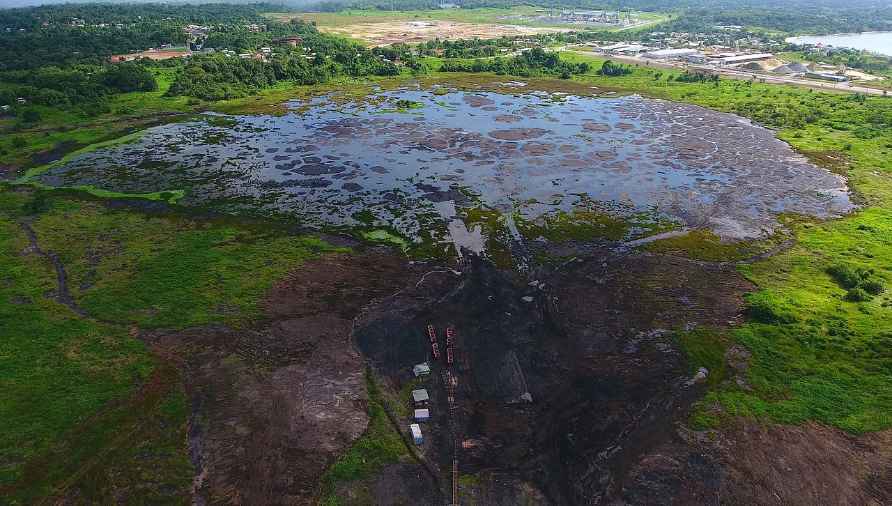
Pitch Lake at La Brea shows how old Trinidad’s hydrocarbon story is. The lake covers about 0.4 km², is about 76 m deep and holds an estimated 10 million tons of asphalt. Walter Raleigh used its pitch to caulk his ships in 1595, and Lake Asphalt of Trinidad and Tobago still mines it today.
Barbados has no comparable oil or gas. For about a century after the 1640s, sugar made it the richest European colony in the Caribbean, and by that period the island had more windmills per square mile than anywhere except the Netherlands. Since independence it has moved into tourism, international business and offshore finance, and it ranks among the Caribbean’s leading tourist destinations. That model has been fragile. In June 2018 Barbados defaulted on its bonds, after its debt had climbed to about US$7.5 billion, more than 1.7 times the size of its economy.
Local prices explain the reversal. Prices in Barbados are high, so each dollar of income buys less on the island, and its PPP figure falls below its nominal one. Prices in Trinidad and Tobago are lower, which pushes its PPP figure well above its nominal one.
Indo-Trinidadians and Afro-Bajans: two different population histories
The biggest social difference comes from labour history. Both islands were sugar colonies worked by enslaved Africans. Barbados was settled by the English from 1627 and stayed an English, then British, colony until independence. Afro-Bajans and people of mixed ancestry now make up close to 90 percent of its people, and Euro-Bajans about 5 percent.
Trinidad took a different route after slavery ended under the Slavery Abolition Act of 1833. When freed people refused to go back to the sugar estates, the colony brought in indentured workers from India between 1845 and 1917. Their descendants, Indo-Trinidadians and Tobagonians, are now the largest group at about 35.4 percent. Afro-Trinidadians and Tobagonians follow at about 34.2 percent, and people of mixed heritage make up around 23 percent. The balance differs sharply between the islands. In the 2011 census only 2.5 percent of Tobago’s people were of Indian descent, and 85.2 percent were of African descent.
This history shapes the national calendars. Trinidad and Tobago Carnival, held on the Monday and Tuesday before Ash Wednesday, gave rise to calypso and soca and to the steelpan, which developed on the island in the 1930s and 1940s. Hosay and Diwali are also major public festivals. Barbados’s main festival is Crop Over, a harvest celebration that began on the sugar plantations in 1687.
1962, 1966, 1976, 2021: two different routes to a republic
Both countries belonged to the short-lived West Indies Federation from January 1958, and Port of Spain served as its de facto capital. When the federation collapsed, Trinidad and Tobago became independent on 31 August 1962 under Eric Williams (1911–1981). His People’s National Movement then won every general election until his death. The country became a republic on 1 August 1976. Republic Day is marked each year on 24 September.
Barbados became independent on 30 November 1966 under Errol Barrow (1920–1987), known as the country’s Father of Independence, and was admitted to the United Nations the following month. It stayed a Commonwealth realm, with the British monarch as head of state, for another 55 years. It replaced the monarchy with a ceremonial president on 30 November 2021, its independence anniversary. Both were also among the four founders of the Caribbean Community (CARICOM): the Treaty of Chaguaramas was signed at Chaguaramas in Trinidad on 4 July 1973 and came into force on 1 August.
Weather has treated them differently too. Trinidad and Tobago lies far enough south that hurricanes are rare, although Hurricane Flora crossed Tobago in 1963. Barbados, farther north and east, was struck by Hurricane Janet in 1955, when at least 57 people died and about 8,100 homes were damaged. That was its first hurricane strike in 57 years, and the next came with Hurricane Elsa in 2021.
Whether Trinidad and Tobago counts as part of North or South America is a question of its own, covered in our guide to which continent Trinidad and Tobago belongs to. If you want Barbados’s position on the map in detail, see where Barbados is. And for a closer-matched Caribbean pair, Jamaica against Trinidad and Tobago sets the two most populous English-speaking island nations of the region side by side.