
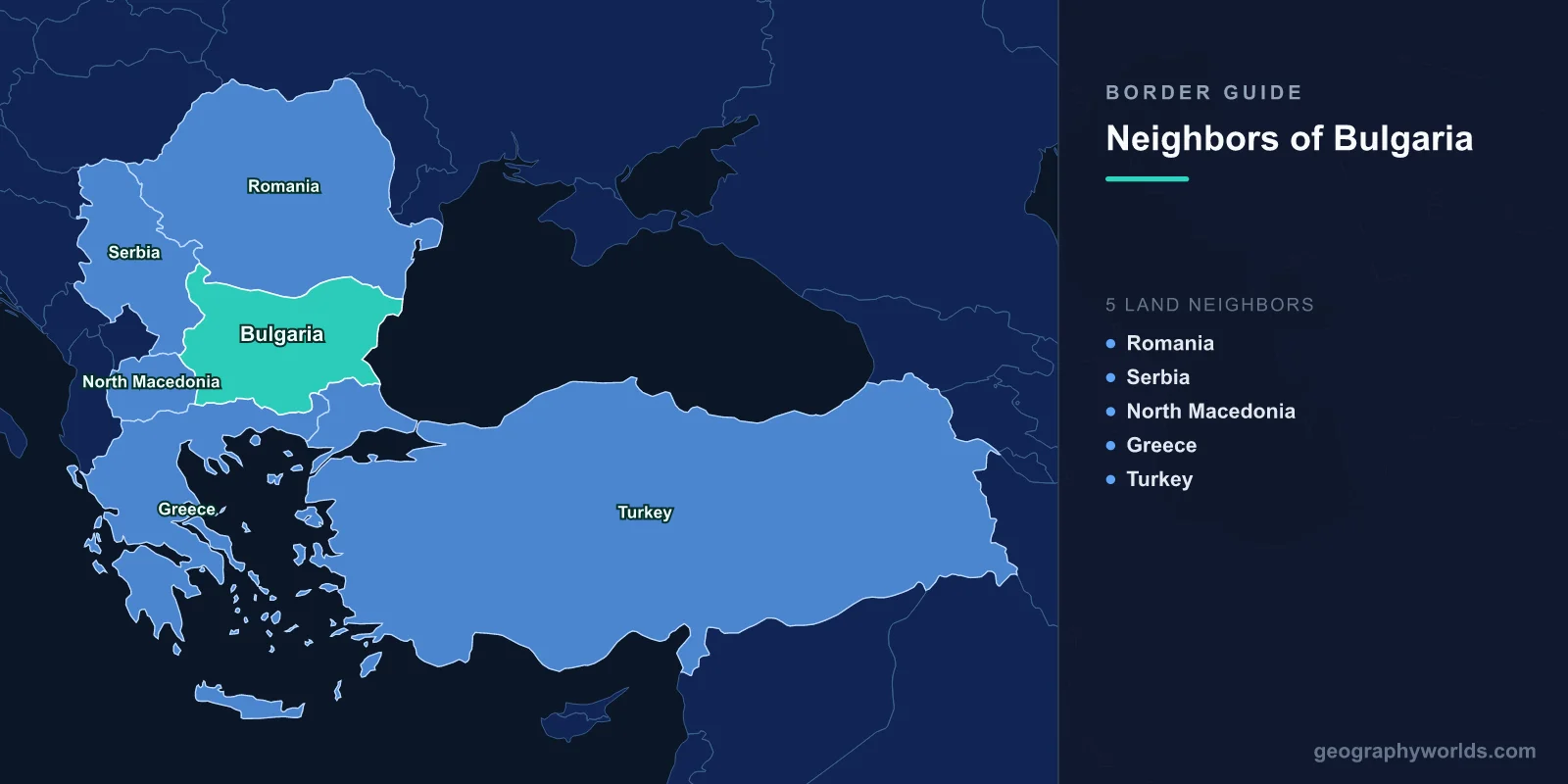
Five countries border Bulgaria: Romania across the north, Serbia and North Macedonia to the west, Greece along the south, and Turkey in the south-east. Together they account for 1,806 km of land boundary, with a further 354 km of Black Sea coastline closing the eastern side. What makes Bulgaria unusually instructive for anyone learning European geography is that no two of those five frontiers work the same way. One is a river, two are mountain chains, one is a plateau line drawn by treaty in 1940, and one carries more freight lorries than almost any other land crossing on the continent.
| Neighbour | Border length | What carries the line | Main road crossing |
|---|---|---|---|
| Romania | 605 km | The Danube, then a plateau line across Dobruja | Ruse–Giurgiu |
| Greece | 472 km | The Rhodope Mountains and Pirin | Kulata–Promachonas |
| Serbia | 344 km | Balkan and Vlasina highlands | Kalotina–Gradina |
| Turkey | 223 km | Strandzha massif and the Rezovska river | Kapitan Andreevo–Kapıkule |
| North Macedonia | 162 km | Osogovo and Maleshevo ranges | Gyueshevo–Deve Bair |
The Danube Does Most of the Work
Bulgaria's longest border is also its least walkable. Of the 605 km facing Romania, roughly 470 km is the Danube itself, running from the Timok confluence near Vidin down to Silistra. It is one of the longest stretches of river boundary anywhere in Europe, and for most of the twentieth century it functioned less as a link than as a moat.
The evidence is in the bridges. For that entire 470 km there were, until recently, exactly two road crossings. The first, the Danube Bridge between Ruse and Giurgiu, opened on 20 June 1954 and was named the Friendship Bridge in the fashion of the period — a 2.2 km road-and-rail structure that for nearly sixty years was the only fixed link between the two countries. The second, the Vidin–Calafat bridge, opened on 14 June 2013 after decades of argument about who would pay, running 1,971 metres and marketed as the New Europe Bridge. Everywhere else, crossing meant a ferry. Two bridges over a shared river longer than the entire Bulgaria–Turkey frontier tells you a great deal about how these neighbours regarded each other during the Cold War, when both were nominally allies inside the same bloc.
The remaining stretch, roughly 130 km from Silistra east to the Black Sea, leaves the water and cuts across the flat Dobruja plateau. That segment is the newest part of Bulgaria's entire boundary. It was fixed by the Treaty of Craiova on 7 September 1940, which returned Southern Dobruja to Bulgaria from Romania and included a population exchange of around 100,000 people in each direction — one of the very few territorial changes of that period never subsequently reversed.
West: A 1919 Treaty Bulgaria Has Not Forgotten
The 344 km facing Serbia runs through highlands where the Balkan range descends into the Vlasina and Krayishte uplands. It was set by the Treaty of Neuilly-sur-Seine on 27 November 1919, the settlement imposed on Bulgaria as a defeated Central Power, which transferred the districts around Tsaribrod and Bosilegrad — the Western Outlands, Zapadni pokrainini in Bulgarian — to the new Kingdom of Serbs, Croats and Slovenes. A Bulgarian-speaking minority remains in both towns, and the transfer is still a live reference point in Bulgarian public memory.
The border's practical importance is the Kalotina–Gradina crossing, carrying the E80 along the old Belgrade–Sofia–Istanbul corridor. It is remarkably close to the capital: Sofia sits little more than 50 km from Serbian territory, making it one of the closest national capitals to a foreign frontier anywhere in Europe. Bulgaria's north-western tripoint, where its territory meets both Serbia and Romania, lies at the mouth of the Timok river on the Danube — a rare case of three countries meeting mid-current.
162 Kilometres, Two Capitals, and Still No Railway
The shortest of the five borders is the one with the most complicated politics. The 162 km facing North Macedonia climbs through the Osogovo and Maleshevo mountains, crossed principally at Gyueshevo–Deve Bair. Bulgaria was the first state in the world to recognise the Republic of Macedonia's independence in January 1992, and has since spent three decades disputing the interpretation of shared medieval history and the status of the Macedonian language, which Bulgarian institutions have long treated as a variant of Bulgarian rather than a separate tongue.
The infrastructure records the estrangement more bluntly than any communiqué. Sofia and Skopje are around 170 km apart by road, capital to capital, and there is still no direct passenger railway between them. The Corridor VIII line intended to connect the Black Sea to the Adriatic has been under discussion since the 1990s and remains unfinished on the Macedonian side. Bulgaria blocked the opening of North Macedonia's EU accession negotiations in November 2020 and lifted the veto only in July 2022, after a French-brokered compromise on constitutional recognition of the Bulgarian minority.
South: Mountains, and the Coastline Bulgaria Lost
The 472 km southern boundary with Greece is drawn almost entirely by terrain. In the west it threads between the Pirin and Rila massifs; across the centre and east it follows the crest of the Rhodope Mountains, a forested range with few passes and a long history of being difficult to police. Practically all north–south traffic funnels down the Struma river valley to the Kulata–Promachonas crossing on the E79, the main route from Sofia to Thessaloniki and the Aegean ports.
That routing exists because of what Bulgaria no longer holds. The same Treaty of Neuilly that redrew the Serbian border also stripped Bulgaria of Western Thrace and its Aegean coastline, including the port then called Dedeagach and now Alexandroupoli. Bulgaria was promised an economic outlet to the Aegean in compensation; it never materialised in any usable form. A country with 354 km of Black Sea shoreline has therefore been cut off from the Mediterranean world for more than a century, which is why so much Bulgarian export traffic still moves overland through Greek ports. Throughout the Cold War this line was also a NATO–Warsaw Pact frontier, mined and closed for decades, with only a handful of crossings open at any time.
Reopening it has been slow work. The crossing at Zlatograd, in the eastern Rhodopes, did not open until 2010, and the Makaza pass — a route through the central Rhodopes used since antiquity — only reopened to traffic in September 2013 after a road tunnel was cut through the ridge. Both were the first new links on that section in living memory, and both immediately shortened the drive from central Bulgaria to the Aegean by several hours.
Where a Million Trucks a Year Queue
The 223 km shared with Turkey is the shortest of Bulgaria's frontiers except the Macedonian one, and by far the busiest. It runs through the rolling oak forest of the Strandzha massif and reaches the Black Sea at the mouth of the Rezovska river — the Mutludere on Turkish maps — at the village of Rezovo, the south-easternmost point in Bulgaria. At the other end, the tripoint with Greece and Turkey sits near the Maritsa river, close to Edirne.
Between those two points lies Kapitan Andreevo, facing Kapıkule on the Turkish side, which together form the heaviest land freight crossing in Europe and one of the busiest anywhere. More than a million lorries pass through it annually, carrying the overland trade between the European Union, Turkey, the Caucasus and the Middle East. When systems slow, the consequences are visible from orbit: queues of waiting trucks have been reported stretching 27 km back along the approach road. Bulgaria has committed over 43 million euros to expanding the crossing's capacity by around a quarter. This is also the stretch where Bulgaria built a barrier — a fence erected in stages between 2014 and 2017 along most of the land boundary, in response to migration routes through Turkey.
What Changed on 1 January 2025
Bulgaria's borders were reclassified twice in nine months. On 31 March 2024 the country joined the Schengen area for air and sea travel, and on 1 January 2025 internal land border controls were lifted as well, alongside Romania. Overnight, two of the five frontiers changed character entirely, because Romania and Greece are the only neighbours inside the passport-free zone. Checks between Bulgaria and Romania at Ruse, and between Bulgaria and Greece at Kulata, simply stopped, ending decades of queuing on routes that carry a large share of the country's trade.
The other side of the same decision is that the Serbian, North Macedonian and Turkish borders became external Schengen frontiers, policed to the standard the whole bloc relies on. Bulgaria now sits on the seam: two neighbours inside the passport-free zone, three outside it, with the heaviest traffic of all crossing at the outer edge.
Five Lines, One Country
Very few states of Bulgaria's size — a little over 110,000 square kilometres — pack in this much variety of frontier: a river border with two bridges, a mountain crest with almost no crossings, a treaty line across a plateau, a disputed history in the hills, and a freight corridor moving a million lorries a year. Learn Bulgaria's five neighbours and you have effectively learned the geography of the eastern Balkans. If you want to fix the arrangement in your head, try placing each of them on a blank map in the map locator game — Serbia and North Macedonia are the pair that trips almost everyone up.