
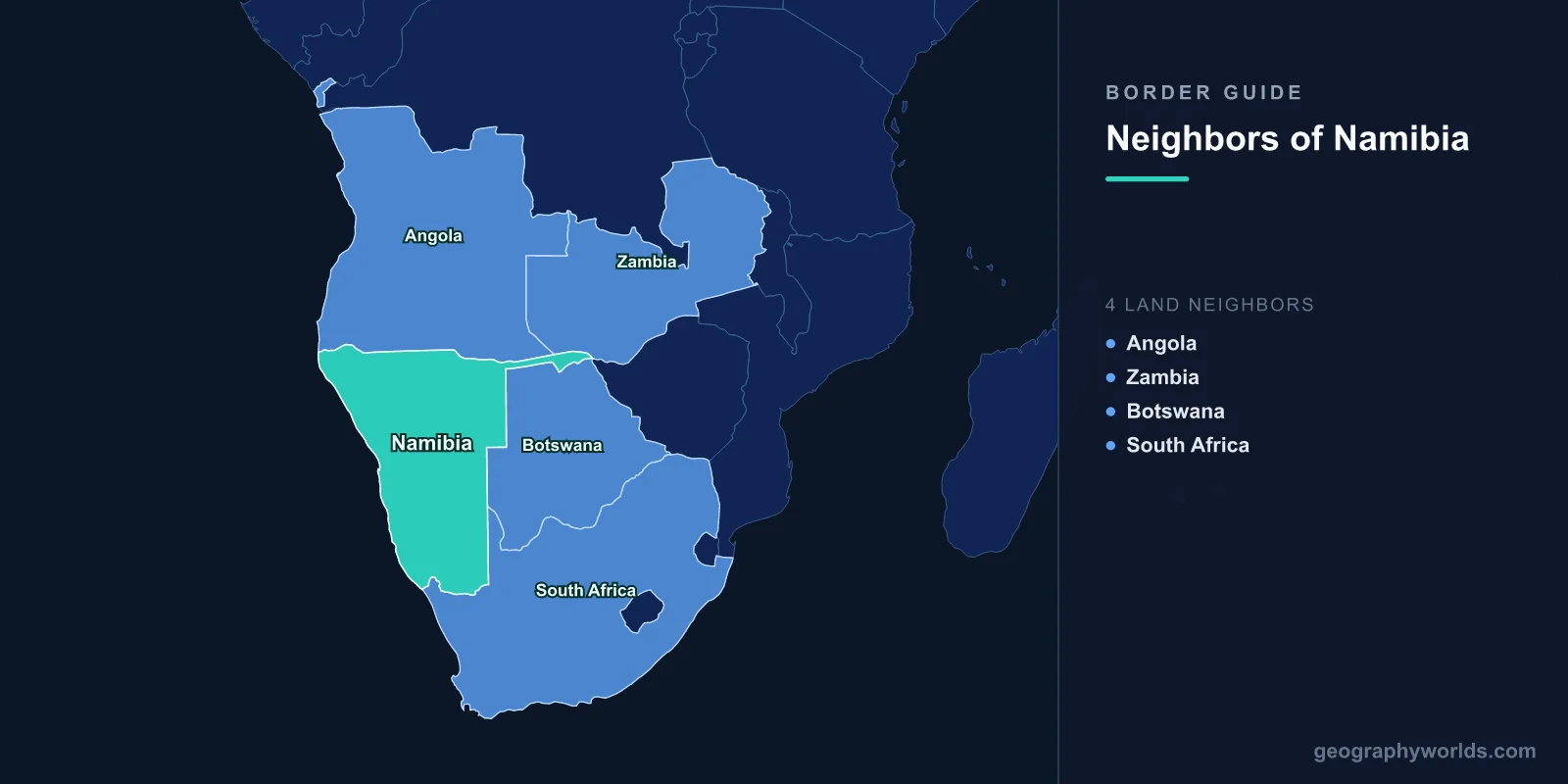
Namibia has four land neighbours. Angola runs along the north, Botswana takes the entire eastern flank, South Africa closes the south, and Zambia touches Namibia for just 244 km at the tip of a narrow arm of territory that looks, on any world map, like a printing error. It is not an error. It is the most deliberate feature of the whole outline, and the reason it exists says far more about European diplomacy in the 1890s than about anything happening on the ground in southern Africa.
The four lines total 4,220 km, set against 1,572 km of Atlantic coast. Botswana supplies the longest stretch at 1,544 km, then Angola at 1,427 km, South Africa at 1,005 km, and Zambia the short remainder.
Three Empires, One Outline
Almost nothing about the shape of Namibia was decided in Namibia. The territory was declared a German protectorate in 1884, wedged between Portuguese Angola to the north and British possessions to the south and east. Over the following four decades, three colonial capitals negotiated the edges of it without much reference to who lived where.
The northern line came first, in a Luso-German declaration of 1886 that ran the boundary up the Kunene River to the Ruacana falls and then struck east along a parallel of latitude. The eastern and north-eastern lines followed in 1890. The southern line had already been fixed on the Orange River. A 1926 agreement signed in Cape Town between Portugal and the Union of South Africa, which by then administered the territory under a League of Nations mandate, tidied the Angolan section into its final form. Three of those four boundaries were drawn by men who had never seen the ground they were dividing.
The Finger of Land Germany Drew to Reach a River It Never Used
On 1 July 1890, Britain and Germany signed the Heligoland–Zanzibar Treaty. Germany dropped its claims to Zanzibar, Pemba and Witu and gained the North Sea island of Heligoland — plus a corridor of land, roughly 450 km long and in places only 32 km wide, extending east from the main body of German South West Africa until it touched the Zambezi River.
The corridor took the name of Leo von Caprivi, the chancellor who had replaced Bismarck two months earlier. Its purpose was straightforward: German planners wanted a river route from South West Africa across the continent to German East Africa and the Indian Ocean. What nobody in Berlin had adequately weighed was Victoria Falls, which sits roughly 65 km downstream of the strip's eastern end and drops the Zambezi more than a hundred metres in a single sheet. Below that come the gorges and, further on, the Cahora Bassa rapids. The Zambezi is not a highway to the sea, and the corridor Germany negotiated for was useless for the one thing it was meant to do.
It turned out to be worth having anyway. Bounded by the Kwando, Linyanti and Chobe rivers to the south and the Zambezi to the north-east, the strip is the wettest, greenest part of a country that is otherwise mostly desert and semi-desert. Namibia renamed the administrative unit the Zambezi Region in 2013. The Katima Mulilo bridge, opened in 2004, finally gave the corridor a real transport function, carrying the Trans-Caprivi route from the port of Walvis Bay through to Zambia and the Copperbelt. At the strip's far eastern point, near Kazungula, Namibia, Botswana, Zambia and Zimbabwe come within a few hundred metres of meeting at a single spot — one of the tightest four-country junctions anywhere.
One Island, Two Channels, and a Judgment at The Hague
The 1890 treaty said the boundary in this area followed the centre of the main channel of the Chobe. Where the river splits around a low, seasonally flooded island of about 3.5 km², that wording became a problem. Namibia held that the main channel was the southern one, which would place the island — Kasikili, in Namibian usage — on its side. Botswana held that the main channel was the northern one, making the island, which it calls Sedudu, Botswanan.
Rather than let it fester, the two governments took the question to the International Court of Justice. On 13 December 1999 the Court ruled by eleven votes to four that the northern channel was the main channel and that the island forms part of Botswana. It also held unanimously that vessels flying either flag are entitled to equal treatment in both channels. Both states accepted the outcome without incident, which makes this one of the cleaner boundary settlements on the continent and a useful counter-example to the assumption that African border disputes end badly. For the wider picture of how this corner of the map fits together, our guide to Botswana's size covers the Kalahari country the rest of that 1,544 km line crosses.
Two Meridians and a Parallel: The Botswana Line
North of the Chobe country, the eastern boundary abandons rivers entirely. It runs south along the 21st meridian east, turns west along the 22nd parallel south, then drops south again along the 20th meridian until it reaches the Orange River. That is the whole geometry: two north–south ruled lines joined by an east–west one, drawn across sand and scrub where no natural feature offered itself. The main crossing is Buitepos on the Namibian side and Mamuno on the Botswanan, the gateway of the Trans-Kalahari Highway between Walvis Bay and Gaborone.
The Orange River Border That Doesn't Run Down the Middle
River boundaries normally follow either the median line or the thalweg, the line of deepest water. The Namibia–South Africa boundary does neither. The 1890 Anglo-German arrangement placed it at the northern high-water bank of the Orange, which means the entire river channel lies inside South Africa. Farmers on the Namibian bank live beside a river that is not, in strict legal terms, theirs to draw from.
Namibia has argued for a median-line boundary since independence in 1990, and South Africa has maintained the historical line; a joint technical commission has met repeatedly over the years without a settled outcome. In practice the two governments cooperate on water allocation and the crossing at Vioolsdrif and Noordoewer on the N7 handles the traffic regardless. The river reaches the Atlantic between Oranjemund and Alexander Bay, in restricted diamond country where the mining licence areas are older than either modern state. Our piece on South Africa's neighbours looks at the same line from the other bank.
Angola: River, Parallel, River
The 1,427 km northern boundary changes character three times. In the west it follows the Kunene from the Atlantic upstream to the Ruacana falls, where a hydroelectric scheme fed by Angola's Calueque dam supplies a large share of Namibia's electricity. In the middle it becomes a ruled line running roughly along 17°23' south, straight across the Cuvelai floodplain. In the east it picks up the Kavango, known downstream as the Okavango, and follows it to the Caprivi corridor.
That straight middle section is the consequential one. It cuts through Oshiwambo-speaking country, the most densely settled region in Namibia, splitting families and grazing land between two colonial systems and later between two states. The crossing at Oshikango, facing Santa Clara in Angola's Cunene province, is the busiest land border Namibia has. It was also a war zone: from 1966 until 1989 the boundary was the front line of the South African Border War, with South African forces mounting operations deep into Angolan territory. Angola's own scale puts that campaign in perspective — the fighting ranged hundreds of kilometres north of the line.
The Four Borders Side by Side
| Neighbour | Length | What the line follows | Principal crossing |
|---|---|---|---|
| Botswana | 1,544 km | Meridians 21°E and 20°E, the 22°S parallel, then the Chobe and Kwando | Buitepos – Mamuno |
| Angola | 1,427 km | Kunene River, a straight line near 17°23'S, then the Kavango | Oshikango – Santa Clara |
| South Africa | 1,005 km | The northern bank of the Orange River | Noordoewer – Vioolsdrif |
| Zambia | 244 km | The Zambezi, along the top of the Caprivi corridor | Katima Mulilo (Wenela) |
Walvis Bay, the Border That Sat Inside the Country
For four years after independence Namibia had a fifth boundary, and it was an internal one. Britain annexed Walvis Bay in 1878 and attached it to the Cape Colony in 1884, before Germany arrived. That administrative accident meant the enclave — about 1,124 km² containing Namibia's only deepwater port — stayed under South African control when the rest of the territory became a League of Nations mandate, and again when Namibia became independent on 21 March 1990.
A newly independent country therefore had customs posts around its own harbour. Negotiations ran for three years before South Africa transferred Walvis Bay and the twelve small offshore guano islands, the Penguin Islands, at midnight on 28 February 1994. The border disappeared overnight, which is a rarer event in African cartography than any of the four that remain.
What is striking about Namibia's boundaries is how few of them describe anything real. One meridian, one parallel, one bank of a river, one arm of land aimed at an unnavigable waterfall — and yet a country of 2.6 million people has made all of it work, settling the one genuine dispute in a courtroom rather than a trench. If you want to see whether you can place Angola, Botswana, Zambia and South Africa around it without checking a map first, our neighbours game will find out quickly.