
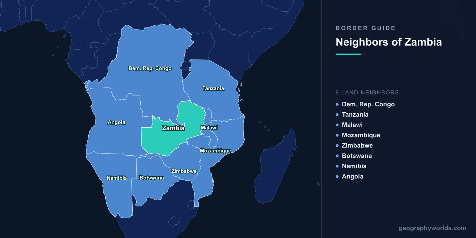
Zambia touches eight countries: the DR Congo, Tanzania, Malawi, Mozambique, Zimbabwe, Botswana, Namibia and Angola. No other country in southern Africa has that many, and worldwide only a short list — China, Russia, Brazil and a few others — does better. The perimeter totals 6,043 km. One of the eight segments is about 150 metres long.
Reading that as a list teaches almost nothing. Reading it as a circuit teaches a great deal, because Zambia's borders were laid down by four different colonial powers arguing over three different resources, and they still determine how every ton of copper leaves the country. So start in the far south-west, at the strangest corner in Africa, and work round.
Kazungula, Where Four Countries Very Nearly Meet
Zambia's boundary with Botswana runs to 0.15 km. That is 150 metres, in mid-river, and it is the shortest international land border in the world. It is short because it is a leftover. Namibia's Caprivi Strip reaches in from the west and Zimbabwe comes up from the east, and instead of the clean four-way meeting point the geography seems to promise, there are two tripoints a couple of hundred metres apart with a sliver of Zambia–Botswana boundary between them.
Zimbabwe spent years arguing the opposite: that all four countries meet at a single point, which would mean any bridge there must cross Zimbabwean water and require Zimbabwean consent. Botswana and Zambia disagreed, and built the bridge. The Kazungula Bridge opened on 10 May 2021, 923 m of road and single-track rail costing about US$259 million, and it curves noticeably in plan for one reason only: the curve keeps the entire structure inside that 150-metre sliver. It replaced a pontoon ferry that could carry two trucks at a time and routinely left queues standing for days. For a sense of what sits on the other bank, Botswana is a much larger country than its population suggests, and almost all of its northern traffic funnels through this one point.
West Along the Zambezi: a Chancellor's Corridor
From Kazungula the border runs west for 244 km with Namibia, almost all of it the Zambezi and the Chobe floodplain. What it is really following is the Caprivi Strip, and the strip exists because of the same Anglo-German agreement of 1 July 1890 that reshaped East Africa. Germany wanted its South West African colony to reach the Zambezi and, through it, the Indian Ocean. Britain conceded a corridor barely 30 km wide and several hundred long, and it was named for Leo von Caprivi, the chancellor who succeeded Bismarck.
Nobody in Berlin had established what lay downstream. Victoria Falls lies downstream, and below it the Batoka Gorge: the river is unnavigable for hundreds of kilometres, and the corridor never delivered a single ton of cargo to the sea. The shape outlived the ambition, through South African administration and Namibian independence, and now carries a rather different traffic. Sesheke and Katima Mulilo face each other across the water, joined by a bridge since 2004, and the Trans-Caprivi Highway running through them gives Zambian copper a route to Walvis Bay on the Atlantic.
Angola: 1,065 km of Straight Lines Through Sand
Turning north-west, the Angolan border is Zambia's second longest at 1,065 km, and much of it is ruled line rather than natural feature — the residue of Anglo-Portuguese negotiation and a 1905 arbitration by King Victor Emmanuel III of Italy over the extent of Barotseland. Across the Kalahari sand-veld of Zambia's Western and North-Western provinces there is often nothing on the ground to mark it at all.
The far north-western tip is worth knowing: at Kalene Hill in Mwinilunga district, within a few kilometres of both Angola and the DR Congo, a spring in a patch of forest is the source of the Zambezi. The river that defines Zambia's entire southern boundary begins about as far from it as the country allows.
This border has moved more people than any other. Zambia sheltered Angolans through nearly three decades of civil war; Mayukwayukwa, opened in 1966, is among the oldest refugee settlements in Africa, and Meheba grew to hold tens of thousands more. Large-scale repatriation followed the 2002 ceasefire, with a residual caseload eventually offered local integration. Now the traffic is changing direction again: the Lobito Corridor project, backed since 2023 by American and European financing, aims to rehabilitate the old Benguela railway from the Atlantic to the Zambian border near Jimbe, which would give the Copperbelt a westward outlet for the first time in fifty years. Angola is a far bigger country than most people picture, and that railway has to cross nearly all of it.
The Congo Pedicle, and the Border That Cuts Zambia in Two
The DR Congo accounts for 2,332 km, more than a third of Zambia's entire perimeter. Its origins lie in an 1894 Anglo-Congolese agreement that used the Luapula River, Lake Mweru and the watershed between the Congo and Zambezi basins — sensible enough on a hydrological map, awkward on an administrative one.
The awkwardness has a name: the Pedicle. A wedge of Katanga roughly 100 km deep drives south into Zambia, separating Luapula Province from the Copperbelt almost completely. To get from Mufulira to Mansa you either drive the Pedicle Road — about 73 km through Congolese territory, tarred and paid for by Zambia's Road Development Agency and reopened in 2016 — or you go the long way round and add several hundred kilometres. Zambia built and financed a highway inside another country because the alternative was worse.
Further west along the same border sits Kasumbalesa, north of Chililabombwe, the busiest crossing in the region and the throat through which Congolese copper and cobalt pass on their way to Durban. Queues of several thousand trucks have been recorded there. Given the state of most of the DR Congo's nine land borders, the Zambian one is unusual in being both heavily used and reasonably functional.
Tanzania, and the Railway China Built to Break a Blockade
The Tanzanian border is only 353 km, running from Lake Tanganyika east across the Mbeya highlands, but per kilometre it may be the most consequential Zambia has. On the lake sits Mpulungu, Zambia's only port — a genuine working harbour in a landlocked country, linked by ferry to Kigoma and Bujumbura.
The railway matters more. After Rhodesia's unilateral declaration of independence in 1965, Zambia's copper exports were hostage to routes running south through hostile territory. Zambia and Tanzania asked the World Bank and Western governments to fund a rail link to Dar es Salaam and were refused. China agreed. TAZARA was built between 1970 and 1975 by something like 50,000 Chinese workers alongside tens of thousands of Tanzanians and Zambians: 1,860 km from Kapiri Mposhi to the Indian Ocean, with roughly 300 bridges and 22 tunnels, handed over in 1976. It has run well below capacity for decades, and in 2024 Zambia and Tanzania signed a thirty-year concession with a Chinese state contractor to rebuild it. Alongside the tracks, the Nakonde–Tunduma road crossing is one of the busiest in eastern Africa.
Malawi and Mozambique: the Quiet Eastern Wall
Malawi takes 847 km, following the Nyika Plateau escarpment and then the watershed between the Luangwa valley and the Lake Malawi drainage — one of the few Zambian borders that a walker could actually read off the landscape. Mchinji, on the Lusaka–Lilongwe road, is the main gate, and Chipata on the Zambian side functions half as a Malawian market town.
Mozambique's 439 km is the least travelled of the eight. It runs down the eastern edge of the Luangwa valley to the point where the Luangwa meets the Zambezi at Luangwa town — the Zambia–Zimbabwe–Mozambique tripoint. The crossing at Chanida feeds the Nacala corridor, the shortest rail route from Zambia's eastern province to the sea, and one that has repeatedly been announced as transformative without quite becoming so.
Home Down the Zambezi: Zimbabwe
The last 763 km closes the loop, and it is entirely river: the Zambezi from the Luangwa confluence back to Kazungula, swelling in the middle into Lake Kariba. Three points on it matter. The Victoria Falls Bridge, thrown across the gorge in 1905, is a border crossing that people travel thousands of kilometres to look at. The Kariba dam wall doubles as a road crossing and a jointly owned power station. And Chirundu, 140 km from Lusaka, became Africa's first one-stop border post on 5 December 2009, under an agreement letting officers from each country work inside the other's territory — a genuinely radical arrangement that cut clearance times sharply when it worked.
| Neighbour | Border length | Principal crossing | What moves across it |
|---|---|---|---|
| DR Congo | 2,332 km | Kasumbalesa | Copper and cobalt heading for Durban |
| Angola | 1,065 km | Jimbe | Little today; the Lobito rail corridor is the bet |
| Malawi | 847 km | Mchinji | Regional trade, maize, people |
| Zimbabwe | 763 km | Chirundu | The main southern route to Beitbridge and Durban |
| Mozambique | 439 km | Chanida | Nacala corridor freight |
| Tanzania | 353 km | Nakonde–Tunduma | Everything that does not go south |
| Namibia | 244 km | Katima Mulilo | Copper bound for Walvis Bay |
| Botswana | 0.15 km | Kazungula Bridge | Traffic routed to avoid Zimbabwe |
Eight Borders, Five Ways to the Sea
Zambia is landlocked, and no point in the country is closer than about 700 km to salt water, but every usable route is far longer than that: 1,900 km to Dar es Salaam, roughly 2,300 km to Durban, comparable distances to Beira, Nacala, Walvis Bay and eventually Lobito. Transport routinely accounts for a third or more of the landed cost of imports.
Which reframes the whole list. Eight neighbours is not a piece of trivia about a crowded map. It is the reason a country with no coastline has five separate corridors to the ocean and can switch between them when a war, a drought or a border closure shuts one down — something Zambia has had to do repeatedly since 1965. Very few landlocked countries have that many exits, and the ones that do tend to be worth studying in a round of naming a country's neighbours, where Zambia is one of the hardest questions on the board.